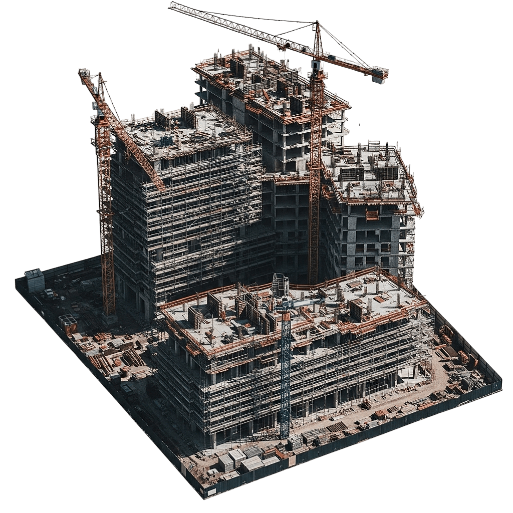
air drone one

Proof of Progress at Every Stage

air drone one

If You Can’t See the Site, You’re Not Really Managing It

Missed Details on the Ground Become Expensive Surprises in the Schedule. Because no project owner wants to hear about a delay or defect when it’s already cast in concrete.

24/48 hr

fast-tracked
reporting

Construction Moves Fast—Miscommunication Moves Faster

What You Don’t Document Now Becomes “He Said, She Said” Later

― Work changes hourly while decisions come from conference rooms and inboxes. Site walks catch fragments—limited angles, overlapping trades, issues buried or poured over. Weekly "on track" reports turn into unprovable critical delays.

― Without overhead views, foundations, staging, access, and safety become guesswork. Materials end up in the wrong place. Subcontractors blame each other. Owners doubt pay apps. Later disputes mean photo/email digging—not time-stamped proof. Weak documentation hits the least-leveraged party hardest.

Aerial Monitoring That Turns Your Jobsite Into a Living Record

― From Dirt to Final Punch, Every Stage Captured From Above

― Air Drone One monitoring delivers consistent bird's-eye views across your entire build lifecycle. Scheduled flights capture site conditions, vertical progress, logistics, and safety from unmatched vantage points. Deliverables are designed for progress meetings, lender updates, and dispute review—not marketing reels.

― In simple terms: unbiased overhead truth—clear for owners, detailed for pros. Owners/lenders gain confidence. Contractors gain protection. Everyone works from one record.

How Monitoring Works

Flights are scheduled around your project milestones—site prep, foundation, structure, MEP rough-in, enclosure, and final stages—so every critical phase is visually captured at the right time.

Certified pilots fly pre-planned routes over the site to record 4K imagery and video from consistent angles and elevations, creating a repeatable visual timeline of the entire project footprint.

Aerial views reveal material staging, laydown areas, crane locations, access routes, and emerging structures in context. You see how each trade interacts with the rest of the site—not just their corner of it.

Edited visuals and progress reels are delivered in owner-ready and site-team-ready formats. Shareable links keep stakeholders aligned without requiring anyone to step onto the jobsite.

Each new flight is layered against prior captures so you can quickly spot acceleration, stagnation, or deviations from the planned sequence.

precision

air drone one

For Teams Who Need Proof, Not Just Updates

― Developers & Owners needing clear, independent visibility on whether the project is truly on pace

― General Contractors coordinating multiple trades and defending progress against claims and complaints

― Construction Managers responsible for reporting up to ownership and down to site teams

― Lenders & Investors who want visual confirmation that draw requests match reality

― Insurance & Risk Managers needing documented site conditions over time

What a Bird’s-Eye
View Does for Your Project

From “I Think” to “Here’s Exactly What It Looked Like”

― Instead of relying on anecdotes, cropped photos, or filtered updates—you operate with a neutral, time-stamped visual record.

What a Bird’s-Eye
View Does for Your Project

― Time-sequenced aerials show when areas were ready, when trades mobilized, and what actually held the schedule back—so you spend less time arguing and more time fixing.

Align
Stakeholders Quickly

― Project meetings move faster when everyone can see the same top-down view. Owners, architects, and contractors talk about the same reality, not different mental pictures.

Improve
Site Logistics

― Overhead shots reveal bottlenecks in material flow, equipment placement, and access routes, enabling you to reconfigure the site for smoother daily operations.

Strengthen Safety Oversight

― Aerial monitoring highlights congested zones, informal shortcuts, and risky storage patterns that might not be obvious at ground level—helping you address hazards before they become incidents.

Support Change Orders & Claims

― When scope changes, weather events, or access issues arise, you have visual documentation to back up change orders, extensions of time, and risk allocation.

Reassure Lenders & Investors

― Regular aerial updates show visible progress tied to the construction timeline, reinforcing confidence that funds are producing real, measurable advancement.

Create a Visual Build History

― From first excavation to final paving, you end with a complete visual story of the project—valuable for future expansions, maintenance planning, and marketing.

Run by Someone Who Understands Property, Not Just Drones

Real-World Asset Management Mindset, Aerial Technology Execution

Air Drone One stems from property management experience—not hobby drones. The same condo risk monitoring mindset now handles construction chaos: reduce unknowns, document reality for meetings, negotiations, disputes.

― That background shapes flight plans, visuals, deliverables. Not social media footage—project evidence for progress reports, lender updates, close-outs. Clarity cuts noise, opinions, selective memory.

Teams Who Stopped Arguing About Progress and Started Seeing It

Trusted by Florida’s Top Real Estate Professionals

air drone one

See Your Project the Way Decision-Makers Need to See It

― Turn Every Phase Into Documented, Defensible Progress

― Your site will keep changing whether you’re watching from the sky or not. The difference is whether you’ll have proof when questions, delays, or disputes appear. Put a consistent aerial record in place now—before the next milestone becomes a debate instead of a confirmation.

FAQS

Straight Answers About Aerial Project Monitoring

Most projects benefit from bi-weekly or milestone-based flights. High-velocity phases may justify weekly monitoring to keep pace with rapid changes.

No. Routes and timing are coordinated with site management to respect crane operations, deliveries, and safety protocols while staying compliant with airspace rules.

Yes. Deliverables are formatted for project updates, owner presentations, lender reports, and internal coordination.

No. Aerial monitoring complements boots-on-the-ground inspections by providing context and proof that ground-level views cannot capture.

Access to imagery and reports is controlled and shareable only with the stakeholders you authorize.

Absolutely. Flights and final edits can emphasize particular structures, phases, or problem zones you want to track more closely.

air drone one

protecting your assets

▫ Quick / Links
▫ Reach / Us
▫ service / Area

We’re actively looking for qualified drone operators to support the inspection services featured on our site. If you’re licensed, detail-oriented, and experienced in aerial inspections, join us in delivering accurate, safe, and efficient drone data for residential, commercial, and industrial projects.

* Upload Your Own Drone Footage for Evaluation (Video or Zip files allowed up to 100 MB)